


FRANKLIN TWP Voting District, Huntingdon County, Pennsylvania
About
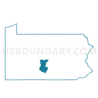
Outline

Summary
| Unique Area Identifier | 659913 |
| Name | FRANKLIN TWP Voting District |
| County | Huntingdon County |
| State | Pennsylvania |
| Area (square miles) | 31.47 |
| Land Area (square miles) | 31.47 |
| Water Area (square miles) | 0.01 |
| % of Land Area | 99.98 |
| % of Water Area | 0.02 |
| Latitude of the Internal Point | 40.69034410 |
| Longtitude of the Internal Point | -78.06375410 |
Maps


Graphs
Select a template below for downloading or customizing gragh for FRANKLIN TWP Voting District, Huntingdon County, Pennsylvania


Neighbors
Neighoring Voting District (by Name) Neighboring Voting District on the Map
- BARREE TWP Voting District, Huntingdon County, PA
- FERGUSON TWP VTD WEST, Centre County, PA
- LOGAN TWP Voting District, Huntingdon County, PA
- SPRUCE CREEK TWP Voting District, Huntingdon County, PA
- WARRIORS MARK TWP Voting District, Huntingdon County, PA
- WEST TWP Voting District, Huntingdon County, PA
Top 10 Neighboring County Subdivision (by Population) Neighboring County Subdivision on the Map
- Ferguson township, Centre County, PA (17,690)
- Warriors Mark township, Huntingdon County, PA (1,796)
- Logan township, Huntingdon County, PA (678)
- West township, Huntingdon County, PA (571)
- Barree township, Huntingdon County, PA (469)
- Franklin township, Huntingdon County, PA (466)
- Spruce Creek township, Huntingdon County, PA (240)
Top 10 Neighboring Place (by Population) Neighboring Place on the Map
Top 10 Neighboring Unified School District (by Population) Neighboring Unified School District on the Map
- State College Area School District, PA (92,270)
- Tyrone Area School District, PA (12,928)
- Juniata Valley School District, PA (5,162)
Top 10 Neighboring State Legislative District Lower Chamber (by Population) Neighboring State Legislative District Lower Chamber on the Map
Top 10 Neighboring State Legislative District Upper Chamber (by Population) Neighboring State Legislative District Upper Chamber on the Map
Top 10 Neighboring 111th Congressional District (by Population) Neighboring 111th Congressional District on the Map
Top 10 Neighboring Census Tract (by Population) Neighboring Census Tract on the Map
- Census Tract 9503, Huntingdon County, PA (7,862)
- Census Tract 119.02, Centre County, PA (6,717)
- Census Tract 9502, Huntingdon County, PA (3,573)
- Census Tract 9501, Huntingdon County, PA (1,803)